New AI-supported Chesapeake Bay Watershed stream maps will help prioritize restoration projects
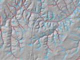
A dataset released last week more than doubles the documented stream miles in the Chesapeake Bay Watershed, elevating the total from approximately 100,000 to over 200,000 miles. The Hyper-Resolution Hydrography Data used to generate the new stream maps stems from a collaboration between UMBC, the EPA’s Chesapeake Bay Program (CPB), and the Chesapeake Conservancy (CC), including UMBC alumni at CBP and CC.
The project lays a robust foundation for the sustainable management of one of North America’s most critical ecosystems, which spans six states and supports millions of residents and iconic wildlife, such as blue crabs and migrating shorebirds. The novel, AI-supported mapping method the research team used also dramatically reduces costs, time, and labor required for stream mapping, making it easy to update as additional data become available or apply in other watersheds.
“The landscape is shaped by running water. Stream networks are the primary conduit between the watershed and the Bay, and now we can characterize that connection in ways that we’ve never been able to before,” says Matthew Baker, UMBC professor of geography and environmental systems, and a lead on the mapping project.
Read more about this work on UMBC News.
Posted: July 1, 2025, 11:05 AM